Was Chortitza in Russia or Ukraine?
Was Chortitza in Russia or Ukraine?
Copyright 2025 by Barry Teichroeb. All rights reserved. www.mooserungenealogy.com
Introduction
When I was young I heard my elders speaking Low German frequently. I assumed my ancestors were German. Years later when I began doing genealogical research I learned quickly that my ancestry was mostly Netherlandic and not German at all.
Similarly, my grandfather was a Russlander. He came to Canada in 1925 from the Mennonite settlements along the Dnieper River carrying a Russian passport. He considered himself a Russian citizen fortunate to have escaped the madness of Stalinist Russia. He often spoke to my Canadian born father about how he would like to return to Russia to search for his elder sister who stayed behind when the family emigrated, but he feared that the Russia secret police would arrest him as a traitor (he fought against the Bolsheviks in the White Army). When my grandfather was younger he fought against the insurrectionist forces of Nestor Makhno, engaged in the War of Ukrainian Independence. This raises a question; if the native Ukrainians were fighting to recover their country, could this country ever be truly identified as Russia or was it simply Ukraine occupied by Imperial Russia?
In 1789 Mennonites from Prussia established the settlement of Chortitza following an arrangement made with Imperial Russia. Chortitza was situated on the west bank of the Dnieper River, 250 km northeast of the northern coast of the Black Sea. At that time Imperial Russia called the region South Russia, or sometimes Little Russia. Today the region is the easterly part of Ukraine. For Mennonite genealogists researching their ancestry the question they often raise is: “Should the location of the Chortitza Settlement be referred to as Russia or as Ukraine?” The geographic location of Chortitza is at the point where the river widens and just north of where it bends dramatically to the west. To understand why that particular land was available for settlement in 1789, and to understand the events that happened in the region after the collapse of the Tsarist regime in 1917, it is helpful to know the answer to the question.
This article will seek an answer to this question by examining the history of the region and the evolution of the political borders as historical events shaped them.
The Varangians
In the eighth and ninth centuries waves of Scandinavian migrations from Sweden toward eastern Europe led to the coalescence of a northern state that became known to history as the Rus State. The migrants were the Varangians. By the tenth century the city of Kiev had become the center of government for the state of the Kievan Rus. The State stretched from the Baltic Sea to the Black Sea, with the southeastern territorial border following the west bank of the Dnieper River.
The map shown below illustrates the territorial extent of the Kievan Rus [1]. Note the elbow of the lower Dnieper River where it widens, just north of the Black Sea. The future Chortitza Settlement was located north of the westward bend.
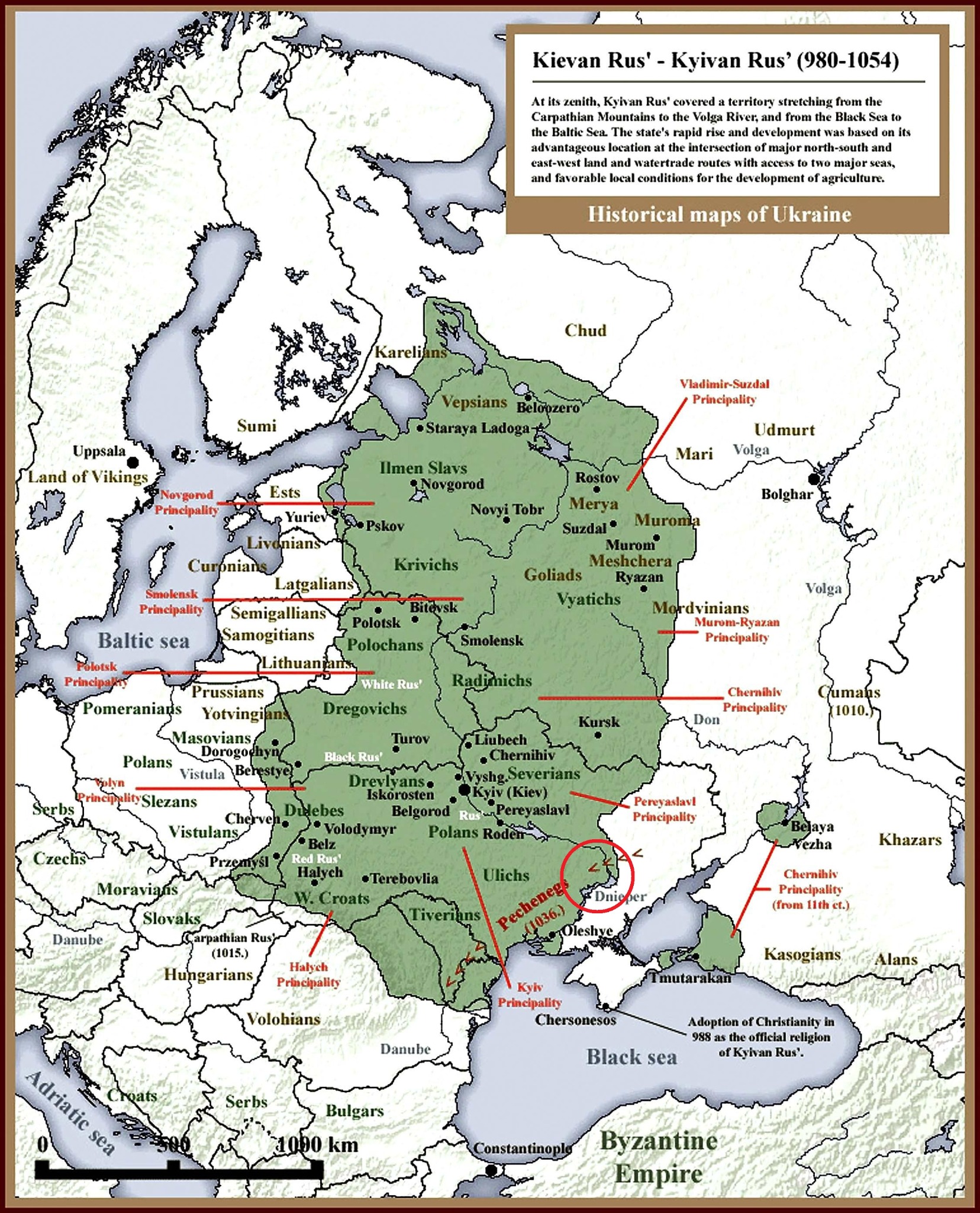
The territory of the Kievan Rus overlaps the borders of modern Ukraine and the western fringe of modern Russia. However, the states of Ukraine and Russia did not exist at this time. The State of the Kievan Rus represents a consolidated cultural group of Europeans separate from other ancient tribes, predating the modern nation-states we recognize today.
Ukraina
The Hypatian Codex is a fifteenth century history of the Kievan Rus. The codex is important for the insight it provides into the ancient Kievan Rus State. It is particularly relevant to this discussion because it contains the first recorded reference to a cultural group known as the Ukraina. The document details the death of a leader of Pereyaslavl, one of the Principalities of the Kievan Rus, with its capital city of Pereiaslav on the eastern bank of the Dnieper, 75 km south of Kiev. The Codex tells us that the Ukraina people mourned the death of their leader. Just as the city of Kiev still thrives in modern Ukraine, so does the city of Pereiaslav.
This information is important because it describes a unique, well defined cultural group with an identity and a geographic homeland existing in the Kievan Rus. These people are the Indigenous Ukrainians.
Mongols
In the thirteenth century Mongol invaders swept westward through eastern Europe, conquering much of the Kievan Rus. These people, the Golden Horde, occupied the entire southern expanse of the Kievan Rus state. Territorial conquest by the Horde reached its peak in the fourteenth century. Internal disruptions and fragmentation, combined with invasions by foreigners, led to the gradual decline of the Mongol Empire.
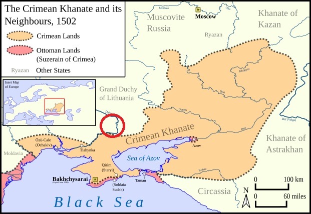
A remnant of the Golden Horde survived and retained the southeastern territory of the former Kievan Rus, on the east bank of the Dnieper River. This region became known as the Crimean Khanate. The map shown below highlights the Khanate in relation to other states after the demise of the Golden Horde [2]. On the east side of the lower Dnieper River is the future location, four centuries later, of the Mennonite Colonies of Molotschna, Bergthal, and Fuerstenland.
The Grand Duchy of Lithuania
By the middle of the fifteenth century, a polity known as the Grand Duchy of Lithuanian was growing powerful and consolidating territory. The region constituting the former Kievan Rus fell into the hands of the Grand Duchy. This territory extended south to the Black Sea, along the west bank of the Dnieper River, encompassing the land that would one day host the eighteenth-century villages of Chortitza. The map below shows the extent of the territory of the Duchy [3].
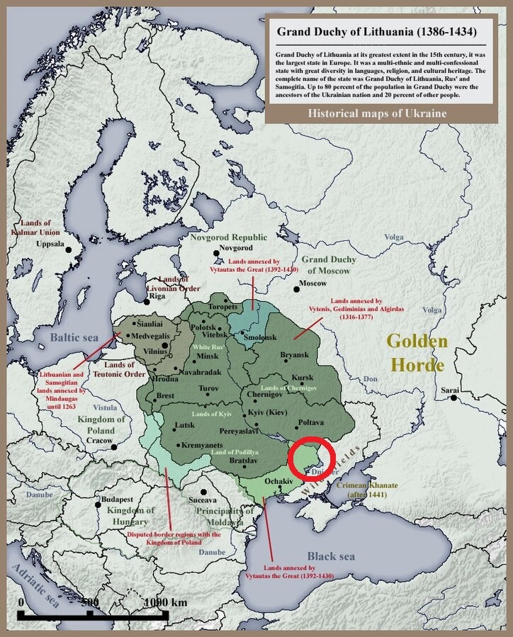
In the map, to the northeast of the Grand Duchy of Lithuanian, is the Grand Duchy of Moscow, also known as the Grand Principality of Muscovy. Muscovy consolidated territory up to the eastern edge of the former Kievan Rus around the same time as Lithuania was absorbing the territories of the old Kievan Rus State.
Ivan the Terrible
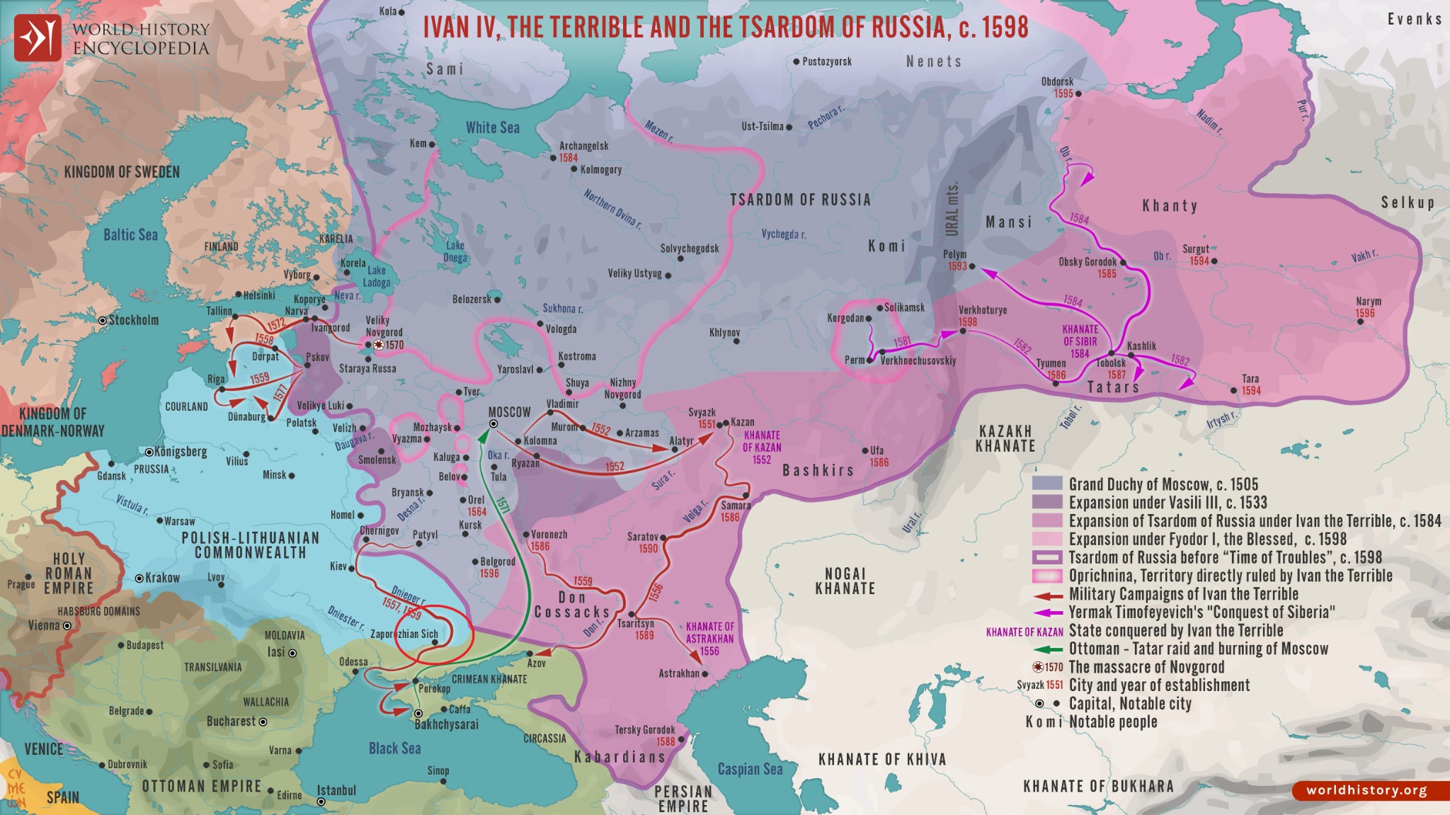
Successive Princes of Muscovy furthered the eastward consolidation of territory. Ivan the Terrible, in the sixteenth century, deemed this Muscovy land the Tsardom of Russia. The Tsardom encompassed eastern fragments of land from the old Kievan Rus State, but the central heartland of the old State remained part of the Grand Duchy of Lithuania. The map shown below illustrates the sharp boundaries between the two states [4]. This map demonstrates that the former Lithuanian Duchy, referred to on the map as the Polish Lithuanian Commonwealth, had expanded since its early days, and had not relinquished territory to the Tsardom of Russia. The ancestral lands of the Ukraina remained in the Polish Lithuanian Commonwealth.
The Cossack Hetmanate
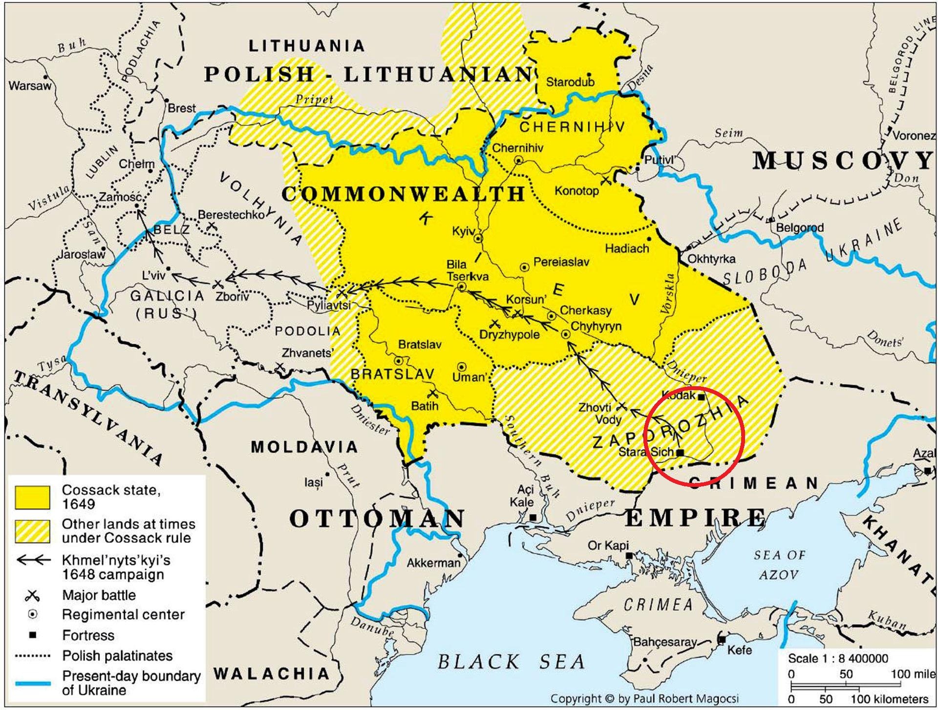
In the mid seventeenth century the Cossack Rebellion, fueled by indigenous Ukrainian grievances against the ruling class of the Polish Lithuanian Commonwealth, led to the establishment of the Cossack Hetmanate. These ethnic Ukrainians were distant descendants of the Ukraina, described earlier in this article. The Hetmanate was a semi-autonomous district in the central and eastern homeland of the ethnic Ukrainians, a carve out of territory belonging to the Polish Lithuanian Commonwealth. The map below shows the region of the Hetmanate and its southeastern border, following the lower Dnieper River as it winds south and turns west towards the Black Sea [5]. The Hetmanate did not include all the territory of the former Kievan Rus. The Polish Lithuanian Commonwealth retained the western lands, and the southern lands remained under the Crimean Khanate.
In its struggle to preserve its newly won independence from the Polish Lithuanian Commonwealth, the Hetmanate formed an alliance with Russia five years later in exchange for protection against the Commonwealth. This alliance was a fatal decision. In time, Russia began to dominate the Hetmanate, referring to it as Little Russia, even while the people living in the Hetmanate referred to the land as Ukraine.
Catherine the Great and Her Annexation Spree
In the mid eighteenth century, about one hundred years after the creation of the Hetmanate, Catharine the Great, ruler of Imperial Russia, abolished the Hetmanate entirely, annexing the Cossack territory. The Indigenous Ukraina lost their ancestral lands and their independence completely. The Indigenous population began a life of serfdom in the service of Russian nobility.
In 1772 the territorial ambitions and combined efforts of the Russian, Prussian, and Austrian empires caused the overthrow of the Polish Lithuanian Commonwealth, leading to its immediate partitioning among the three imperial powers. Thereafter, Catherine annexed the western-most parts of the traditional Ukrainian territory.
The final remnants of the ancient Kievan Rus state, the most southerly regions along the lower Dnieper River reaching south to the Black Sea, which earlier had been under the rule of the Crimean Khanate, was, over time, absorbed into the Ottoman Empire. Catherine violated a Russian treaty with the Ottomans and forcibly annexed the region. With this final act Imperial Russia controlled the entirety of lands associated with the ancestral Ukraina people and the Kievan Rus.
Not much later the Imperial Russian Crown invited Mennonites from the Vistula Delta to settle in the region of the lower Dnieper River. Imperial Russia called the destination South Russia and sometimes Little Russia. The Indigenous people still thought of it as Ukraine. In 1789 this land became the site of the Chortitza Colony.
Conclusion
In the early twentieth century, in the aftermath of the collapsing Tsarist regime of Imperial Russia, Nestor Makhno waged a bloody insurrection to recover the independence of his Ukrainian homeland. Although this War of Ukrainian Independence failed eventually, it demonstrated that the spirit of the Ukrainian heartland had survived centuries of invasion and was undiminished by decades of forced annexation and occupation. Further, history shows clearly that the Tsardom of Ivan the Terrible had never encompassed the ancestral territories of the Ukraina people. The subsequent usurpation of Ukraine was a more modern series of events conducted by Catherine the Great, the product of the aforementioned series of annexations along with military enforcement.
While Ukraine was part of the Russia Empire during a period of Imperial annexation and subjugation, the inhabitants always identified as Indigenous Ukrainians. The Settlement of Chortitza was located within the geographic boundaries historically identified as Ukraine.
Postscript
The Mennonite settlement of Molotschna, established in 1803, was located east of the Dnieper River, about 100 km southeast of Chortitza, close to the Sea of Azov. Bergthal Colony, a daughter Colony of Chortitza, was about 75 km east of Molotschna. Fuerstenland, another daughter colony of Chortitza, was located on the east bank of the Dnieper River, just south of Chortitza. These settlements were continuously part of the territory of the Golden Horde, the Crimean Khanate, and the Ottoman Empire until the eighteenth century when Catherine the Great annexed the territory.
Source Notes
[1] URL of map: https://www.reddit.com/r/MapPorn/comments/zlxc6l/map_of_kyivan_rus_9801054/#lightbox.
[2] URL of map: https://commons.wikimedia.org/wiki/File:Crimean_Khanate_Map_1502.svg.
[3] URL of map: https://commons.wikimedia.org/wiki/File:Grand_Duchy_of_Lithuania_Rus_and_Samogitia_1434.jpg.
[4] URL of map: https://www.worldhistory.org/uploads/images/17874.png?v=1706594643-1695885355.
[5] URL of map: https://www.reddit.com/r/MapPorn/comments/10qtthn/the_cossack_hetmanate_after_the_khmelnytsky/#lightbox.
Post a comment